2. Memoirs ____ (about 45 mins read)A Chapter by Carolamemoir plus 11 photos
2. Memoirs (* Asterisks show explanations for non-aviators) (Bold numbers have detailed explanations in the Footnotes)
After just over 4½ years, from the 2 November 1974 until 6 May 1979, I moved on from my flying instructing job with the Camden Aero Club, and was then involved in casual charter work accumulating more flying experience on multi-engine aircraft. Then on 28th June 1979 after the previous pilot had left, I scored a corporate pilot job with a property development company called Smithfield Mall Pty. Ltd.1 which was privately owned by Garry Dent 2. The company’s office was located in North Sydney, NSW. I don’t remember how I heard about this upcoming flying position vacancy. Maybe it was through the Bankstown (flight) briefing office where pilots used to get their weather forecast and lodge their flight plans etc… this was the place to be for the latest gossip on flying happenings and flying-buzz. And if you wanted to hitchhike a lift somewhere by aircraft, just ask the briefing officers if there were any planes (not airlines) flying to a destination you wanted to get to and then ask if they had a spare seat on their flight. With the advent of computers and the use of phones, attending a briefing office in person at a primary or secondary airport no longer exists these days. Sad, a whole chin-wagging flying-buzz centre is now gone! I heard about my last flying job with Norfolk Jet Aviation via the Sydney briefing office, by meeting a company pilot who informed me of an upcoming vacancy. Smithfield Mall P/L owned a snazzy white and red striped Piper Aerostar 601B which was based at Bankstown airport, a general aviation airport located only a handful of kms/miles from Sydney’s international airport. I lived in Camden, which was southwest and located just outside of the Sydney metropolitan area about 1½ hours' car drive away from the company’s North Sydney office. Bankstown airport is located about midway in distance from my home to the company’s office, and Sydney airport was just over an hour’s drive from home. 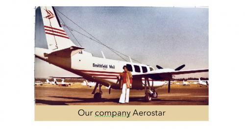 I flew the Aerostar, carrying Garry’s business colleagues, his regular friends, occasionally Garry’s wife and kids and office staff, or his girlfriend or call girl (needless to say the women, were not on board all at the same time!) A little bit more info about the company’s Aerostar… it was a turbo-charged twin-engine, *non-pressurised aircraft with a cabin configuration to seat 5 passengers, plus pilot. It was a mid-wing plane, meaning the wings are attached at a mid-height section of the plane’s fuselage. It is still the fastest 6-place piston twin-engine aircraft in the world today. (*All non-pressurised aircraft cruise up to heights of 10,000ft so passengers can still happily breathe without the need to wear oxygen masks!) Airliner planes are either low-wing or high-wing aircraft, which refers to the wing-to-fuselage attachment point. When you’re looking out of the airport terminal windows and watching aircraft taxiing past, I would say that most non-pilot people unless they are plane spotter enthusiasts, or have flying friends who talk about planes and flying, would never even have noticed which wing attachment their airliner had. Our plane, and I still remember the registration lettering, VH-IXA, was fun and slippery to fly. At an altitude of 8000 ft with a power setting of 65% its cruising speed was 210 knots (389 km /241 mph) that’s 3.5knots per minute and I loved the way it handled. By ‘slippery’ I mean it took a bit longer to slow down than other similar type planes and so of course that used up more slowing up distance. So you needed to plan ahead. Just for fun, and when I knew I was the only aircraft approaching a non-controlled airport, I used to enter the airport circuit pattern at an indicated speed of 200kts. which is 80 kts above the maximum circuit speed. After reducing power, I then used the extra aerodynamic drag during turns to slow down to drop back to the standard circuit speed of 120kts before lowering the gear (undercarriage) and flaps. .…It was a hoot! In May 1980 I had been with the company for about a year when Garry was keen to upgrade our Aerostar for something a bit larger. Garry had confided to me it was to impress his business colleagues and friends and make the company look good and successful. So two aircraft, the Fairchild Swearingen Merlin and the Mitsubishi MU-2B-60 ‘Marquise’ were considered, both being *pressurised *turboprop corporate type aircraft and we were given a demonstration flight in the Merlin. 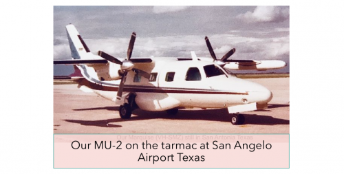 Incidentally, turbo-charged and *turboprop are not the same - the former is a piston engine, whereas a turboprop is a jet engine with a propellor attached. *Pressurised meant the aircraft had an internal cabin pressure somewhere between sea level and 10,000ft and which allows flight at altitudes way above 10,000ft with passengers not requiring the constant wearing of oxygen masks. My luck was in, and Garry selected the MU-2B-60 ‘Marquise’ for lease, so my job was safe from the Merlin salespeople, who were manoeuvring to install their own pilot to go with a Merlin lease. The ‘Marquise’ model Mitsubishi would be the first of its type to come into Australia and go onto the Aussie register. The MU-2 normally could seat up to 11 passengers. Our plane was in a corporate configuration set-up for 9 passengers, which included a bench seat for 3 people and directly opposite was a pull-out table with seats for 2, there was a refreshment centre (bar), some individual seats facing into the cabin and also facing rearwards, and the 2 pilot seats.3 A hot water urn with a storage cupboard underneath was located behind the co-pilot seat, and opposite the only door at the rear of the plane located next to the baggage compartment was a toilet seat with a pull-across curtain….Very convenient for those heavy-drinking passengers! Also, for some unfathomable reason I had always wanted to fly an aircraft that had an onboard toilet. Because our aircraft had its maintenance base at Essendon Airport the only downside to an onboard toilet, was that I was the person that had to clean the loo in between servicing. Well it’s a bit uneconomical to fly from Bankstown in NSW to Essendon in Victoria, 381nm just to have the loo cleaned. …So be careful what you wish for. Although at one time I did need to use this convenience myself when I had to overnight in the plane and sleep on the bench seat. This came about because of disgruntled airport Safety-Systems Technicians (radar) going on strike overpay and conditions during Dec./Jan. 1980-81. So air traffic control placed restricted airspace around many airports which effectively closed them, naturally the closures happened to be only at the frequently used airports close to cities! The company then sent me off to USA for my ‘type training’ /or ‘endorsement’ flight training on the MU-2B-60. This was going to be a new travel adventure for me. I had never travelled overseas before without Peter, my hubby, who knew about travel things such as check-ins, passports, visas, etc., which I had always left up to him when we holidayed in Europe. Australia has firm flight training regulations for pilots wanting to fly different types of aircraft. Unlike Australia, in the USA ‘type training’ for the MU-2B was not a legal requirement. Although after quite a few fatal accidents and many years of pressure from the Mitsubishi company, the FAA (Federal Aviation Authority) finally changed this in 2016 to require pilots to qualify at an approved MU-2B training program, though it is still not classified as type training. This recent training requirement is quite comprehensive and also requires a minimum of 100 flight hours on multi-engine aircraft as PIC (pilot in command) prior to starting any MU-2 training. So on the 18th May 1980 I winged my way across the Pacific on Qantas. Crossing the international dateline and flying eastwards I gained one day and so I arrived in Houston Texas late afternoon on the same day, with no spare days to unwind from any travel jet-lag, and stayed at a motel style accommodation which was close to the ground school. The next morning I attended the ground school at Flight Safety International 4 which was located adjacent to William P. Hobby Airport (HOU airport abbreviation) another large airport in Houston, which is south of the main George Bush Intercontinental Airport. So from Monday 19th May until Friday 23rd I sat in a class with maybe 10-15 people for the ground course which covered the MU2B-60 engines and aircraft systems. Our ground instructor spoke with that quaint hill-billy sounding Texan drawl which my ear was not accustomed to hearing. This drawl frequently made me chuckle out loud in class with his funny (to me) American-English pronunciation of some words, and on some occasions these also needed a translation for me. At that time Flight Safety had not yet acquired a flight simulator for an MU-2 so my flight training was going to be done in the aircraft itself with their instructors. After I completed ground school, I went on to San Angelo Regional Airport / Mathis Field Airport (SJT) in Texas, where the Mitsubishi aircraft factory was located to do my flight training on Garry’s new MU-2, it’s USA registration was N919MA. I do not remember how I got from Houston to San Angelo, whether by bus or airline. However at San Angelo I had to hang around and wait until the 10th June, another 18 days, before starting my flight training, as Garry had not yet signed the lease contract and the Mitsubishi factory was finalising customising the cabin’s corporate passenger configuration. It was whilst waiting at the Mitsubishi factory for access to Garry’s MU-2 that I met the ferry pilot Bill Kelly Jr. 5 who had made his way up from his hometown of Lakeland in Florida. 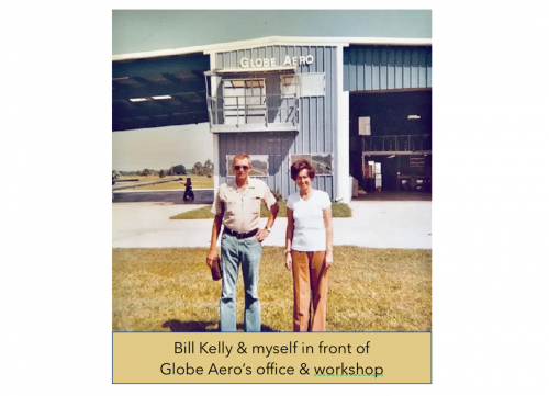 In aviation speak, *’light aircraft’ is any plane below a weight of 12,500 lbs/5,700 kg and there are quite large variations within that GA category from small single seat or two-seater puddle-jumpers to sophisticated aircraft like the MU-2 and Merlin, etc. My MU-2 flight training also paid for by Smithfield Mall P/L, and was done over two days. Starting early in the afternoon of the 10th June, I flew 3:15 hours in one session and the next day flew 4:50 hours in three sessions of 3:10 hours and 0:30 mins, plus a short flight of 1:10 hours flying from San Angelo to San Antonio and return, to pick up my temporary Airman Certificate to comply with the *FAA regulations. (*Federal Aviation Authority).  After I finished my flight training we flew the MU-2 from the Mitsubishi factory base in San Angelo (SJT) Texas on to Globe Aero’s base in Lakeland (LAL) a flight time of 4:30 hours/mins. When I say ‘we’ I mean Bill, with me as a passenger in the co-pilot seat. The plan was that after installing the 3 extra tanks inside the MU-2's cabin, it was to be flown back to the aviation leasing company’s maintenance base at Essendon Airport in Victoria, Australia and I was to accompany the ferry pilot on the flight. Bill was a very seasoned and the most experienced of Globe Aero’s pool of ferry pilots. He was a retired (Commander) Navy pilot and after his retirement, was for some years a test pilot with the Piper Aircraft Corporation. He was well experienced in many Pacific, Atlantic and Indian Ocean ferry crossings of general aviation light aircraft. Interestingly though, Bill had never flown an MU-2 prior to our Pacific crossing, all perfectly legal in USA back then. I was introduced to the owners of Globe Aero, Philip and Donna Waldman.7 Donna very kindly invited me to stay at their home whilst the ferry tank installation was being done, so I also got to experience how Americans live. Donna, kids and I even spent a day at Disney World in Orlando FL. Globe Aero had designed three specially made supplemental metal fuel tanks sized to fit in through the aircraft door, plus the fuel lines which were plumbed back into the MU-2 fuel system. Unfortunately the tanks actual capacity has escaped my memory. The total fuel load from the internal cabin tanks plus the aircraft’s normal tanks ensured we could make it across the ocean with good reserves and not run out of fuel! Globe Aero engineers pulled out all the passenger seating and other interior fittings from the aircraft cabin and installed the three tanks inside, which left us with just enough space for a narrow aisle leading from the door to the cockpit. All the seats and other interior fittings were then stacked in the baggage compartment and the remainder in the (previous) toilet area. I can’t remember now if we had packed a life raft onboard or not in case of an ocean ditching. An old WW2 ‘wobble’ pump was fitted behind the co-pilot’s seat. Bill did explain to me the pump’s purpose, but being so long ago I can no longer remember now why. Was it only to initiate the fuel flow from the internal cabin tanks, or were the pumps required to work continuously for fuel transfer, or was it for rectifying any fuel flow problem that could later occur inflight, or all three events ? Never having been on a ferry flight
I had not seen such a pump arrangement before. Anyway, the plan was to
use the three cabin tanks first, before switching back to the normal
MU-2 fuel tanks. Sadly I can’t
remember how much reserve fuel we carried but I’m guessing that we
carried at the very minimum the standard (for commercial flights) of 15%
of flight fuel, plus the general standard reserve of 45 mins. Looking
in my log book, I see the Bakersfield (BFL) to Honolulu (HNL) total
flight time took us 10 hrs. 20 mins. So I’m guesstimating we carried at
the very least 13 hours of fuel. Globe Aero had also received FAA approval for our aircraft to fly overweight, I vaguely remember a figure of 10% or maybe slightly more. The MU-2B-60’s maximum *ramp weight was 11,625lbs (5273 kg) so we could’ve been overweight by 1,162 lbs /527 kg or more, but I don’t remember our exact figure. (*ramp weight includes the additional fuel required in lbs/kg for taxiing from engine start-up to the take-off point). When Bill had been assigned this ferry job he would’ve spent time going through the Pilot’s Operating Manual (POM) familiarising himself with the aircraft’s systems and doing his sums to calculate the fuel load needed for the the longest leg of the flight to Australia, and how much overweight the aircraft would be. 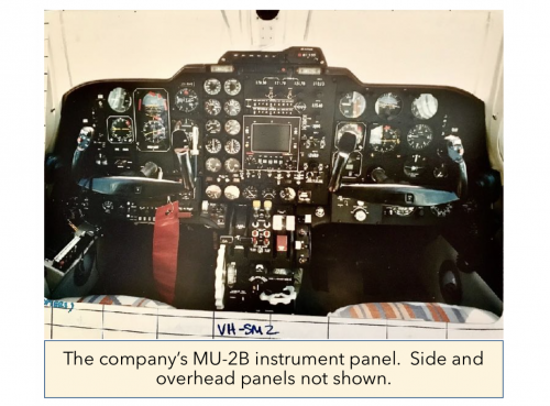 Then he would’ve *extrapolated from the take-off distance chart graph an approximate estimate of our required take-off distance. (*means going outside the limits of a graph). There are shortcomings when extrapolating a graph, in that it relies on untested assumptions of data. Bill probably did all this at the aircraft factory where he had ready access to sit in the cockpit and get familiar with its layout whilst waiting for me to complete my type training. Entirely at his discretion which he didn’t have to, Bill kindly let me log the flight time as ‘In-command-under-supervision’ (ICUS) and I greatly value that he annotated my log book as such, a visual reminder of Bill and the flight. I must mention, whilst still at Lakeland, a few days before our departure, Bill gave me some advice regarding food before our journey. He advised me to stop eating all solid food except dry toast, as it might take about 2 to 3 days to get our bodies into a ‘no residue’ situation, where we didn’t need to go to the toilet for number 2 business. Because once we were en-route to Honolulu we had no toilet, only a plastic bag in case of dire emergency! I decided on the day of our departure I would also avoid drinking my usual coffee, I did take a small bottle of water on board so I could take small sips for hydration during our flight. The tank installation was complete and its functioning had been checked, and all the relevant paperwork for the aircraft and our ‘General Declaration’ for agriculture, customs immigration and public health clearance was done, we planned to leave the next day. On the 19th June, we were on our way. Flying non-stop across USA from Lakeland Florida to Santa Barbara Municipal Airport (SBA) in California situated right on the West coast, about 150 km (94 m) north-west of Los Angeles. I don’t remember if Bill had added a partial amount of fuel to the ferry tanks for this short flight of 4:30 hours/mins duration, just to check out the ferry system fuel flow inflight whilst we were still flying over USA land, or if he'd left them empty. Bill made an interesting comment to me about our Private non-stop flight across the USA. He said it’s possible that the law enforcement authorities may have been alerted by our flight, as a private non-stop flight could signify to them that we might be a drug carrier. And not to be too alarmed if we were greeted by the police on our arrival in Santa Barbara. Anyway, I don’t have any recollection of being welcomed by the police at the airport. So I’m guessing no dramas happened. The next day on the 20th, the winds were too strong for us to start our Pacific crossing, so we remained in Santa Barbara. On the 21st June Bill decided to fly to Bakersfield about 70 miles inland from which to start our ocean crossing. His reasoning being, because of the aircraft’s overweight condition our climb rate would be slower than normal. He wanted to gain as much altitude as possible close to the US coastline, while still receiving the Santa Barbara navigational aid signal before we were out of range and lost it. Unfortunately the winds were still too strong to set off on the following day. Another day later on the 23rd June, the weather forecast and expected winds were favourable for the ocean crossing to Honolulu, and so Bill flight planned, and the aircraft was fuelled-up. So early in the morning, after a total of 4 days weather waiting delay, we were finally off. 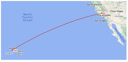 Just how we had occupied our time over those 4 days hanging around the airport and waiting for the right winds and weather I don’t recall. Though I do remember it certainly wasn’t spent eating! We still needed to keep our bodies free of food residue, ’coz we wouldn’t have known which day would be favourable to set off. Perhaps we did a lot of coffee drinking! ☕︎ However I’m fairly sure I would’ve spent more time reading through the MU-2’s POM. It had been either at Lakeland, Santa Barbara or Bakersfield airports (can’t remember which one) that Bill did an alignment check of the aircraft’s standby compass against the airport’s Compass Calibration Pad (CCP) which was painted on the tarmac. It was to check if our newly installed metal tanks inside the cabin had caused any deviation to our magnetic compass reading, which we would need to know and to compensate for. While writing this memoir and just for my own interest and curiosity, I used Google and Bing Maps to see if I could still find a CCP on the tarmac at those three airports. There was only one fancy looking CCP at Lakeland airport on the current 2022 map detail. Though its location would make it unusable now, as buildings and metal aircraft hangars have encroached far too close that would cause a slight magnetic change in that tarmac spot. It’s possible this could now be just an advertisement as a logo is shown at its centre. Since then, I’ve learned that most airports don’t bother keeping these CCPs up to date anymore for cost savings, as updating is needed at least every 5 years. (I have never yet seen one here in Australia, I would imagine compass calibration would be done digitally nowadays.) 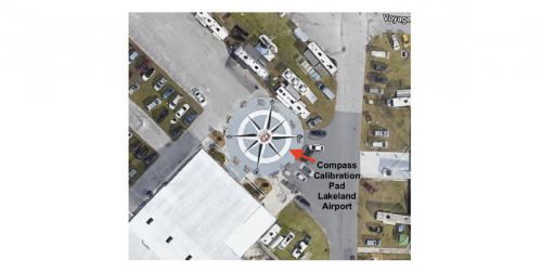 Another consideration Bill mentioned, aircraft normally flown within the northern hemisphere have a Northern hemisphere compass. The compass rose ‘balance-weight’ is on the South end of the compass rose inside its instrument casing in northern hemisphere, and this is vice-versa for southern hemisphere aircraft flying in Australia. The balance weights are to ensure the magnetic compass with its compass rose sitting on a little pivot, remains horizontal and is free to rotate (and doesn’t dip downwards at an angle inside its casing towards the pole, which could impede its rotation). Whilst I’d learned about the compass balance weights many years ago during my *PPL flying theory lessons, I had never myself flown over the equator across the hemispheres from north to south prior to this ferry flight, excepting by airline. So I had never given any further thought to this practicality. (*PPL = Private Pilot Licence) Our sophisticated MU-2 has a slaved directional gyro compass instrument to fly headings, and our magnetic compass only serves as a standby instrument. For non-pilots reading my memoirs, here’s a basic explanation of two different methods of air navigation. For the many general aviation aircraft the standard navigation is by way of radio navigation where onboard aircraft navigation instruments receive radio signals from ground navigation beacons (navaids). Depending on the aircraft’s navigation instrument and the type of ground beacon, your aircraft’s instrument will show your direction or the distance to or from the navaid. Radio navigation charts (RNC) showed the location of all the various beacons, and their radio frequencies, the magnetic tracks and distances between these beacons. The pilot selects the radio frequency of the closest beacons along the flight track to receive their signals and the aircraft instrument shows where you are in relation to a beacon on the chart. (During my flying career they were called RNC charts in Australia. I haven't kept up to date with the Australian aviation industry since retiring. So I don't know if that name, or the charts themselves have remained unchanged, or if Aussie pilots now use the American Jeppeson charts, or maybe it's all digital on a laptop computer now.... or whatever.) Many small aircraft pilots flying visually and not in/above clouds use a combination of Map Reading by observing ground terrain and landmarks against the topography shown on the map, named the World Aeronautical Charts (WAC) and also Dead Reckoning (DR) navigation. DR is calculating your current location by applying a known groundspeed to your track and distance, then calculating a time interval and an estimated time of arrival (ETA) at your next turning point or destination. To calculate your groundspeed you need to know your wind direction and speed and then apply it to the aircraft's normal cruising speed. Some smaller aircraft may happen to have one or two navigation instruments installed, and pilots could use both Radio Navigation in addition to the Map Reading and DR, but before flight they would either need to find out the required navaid locations and those radio frequencies, or have an RNC chart. Most people have mobile phones these days, so they should be familiar with the term GPS. An aside for the younger generation who may be reading this, in the 1980s, there were no convenient handheld mobile phones, though Garry always being avant-garde, did have a car phone which was about the size of a brick and needed to be installed and plugged into a car’s electrical system. It was the closest thing to a mobile phone back then. They were very new at the time and had not been long on the market. I believe GPS for air navigation became operational in airliners sometime in the 1990s. However, on our journey we had no such GPS luxuries. A mobile phone GPS to assist with our ocean navigation at that time would have been wonderful. If you’re now thinking, so what did airliners use for long range navigation in those days prior to GPS ? They did have other forms of onboard navigation systems installed. However these were never installed in light aircraft, for reasons of huge expense, extra weight, no space for it and unnecessary for general aviation aircraft that flew relatively shorter distance flights. As 42 years have passed since that USA-mainland to Hawaii flight, I am now making an assumption that the type of navigational ground beacons for Santa Barbara, Bakersfield and Honolulu back in the 1980s, are the same type now, as those I recently found during my Google search. Our initial navigation after departing Bakersfield, was using the onboard VOR instrument (VHF Omnidirectional Range) utilising the Bakersfield *VOT ground signal. Then overflying Santa Barbara’s *VORTAC ground beacon and then setting off across the ocean using that navaid. The beacon’s range is ‘line of sight’ so we would’ve still received the signal around 200 nautical miles /370 km or so from the US coastline out to sea, before the signal was out of range and disappeared. So the higher our altitude the longer we would receive the Santa Barbara ground beacon signal. * Some airports have a VOT navaid which is simply a VOR beacon with a Test Facility to check your aircraft’s VOR receiver for accuracy. * VORTAC navaid is a merger of VOR and TACAN ground beacons into one navigational aid. The TACAN part is a military system similar to VOR but with higher accuracy. Civil flights use the VOR signals and additionally can also use the *DME part from the TACAN * DME = Distance Measuring Equipment another type of navaid At least this short distance of ground signal reception would give us an indication of the actual wind drift and groundspeed we were experiencing at the beginning of our journey, compared to what was forecast. After losing our VORTAC signal we were back to the very basics of DR navigation and crossed our fingers that the forecast wind speed and direction would not change too drastically en-route, over our distance of about 2206 n.m. so we wouldn’t fly too far north nor south of Hawaii and be out of range from receiving Honolulu’s ground beacon signal. There have been quite a few ferry aircraft, mostly smaller ones than ours that have dropped into the ocean, either with engine problems or running out of fuel due to changed wind conditions or fuel flow problems. Although there was an MU-2 ferry aircraft that in 1988 crashed 8 into the Pacific about 300 nm north-east of Cairns, an Australian town on our north-eastern coastline. I particularly remember one pilot from Bankstown Airport splashing into the Pacific twice with engine problems, they were 2 new aircraft and not second-hand ones. He was lucky enough to survive and be found and rescued both times by the US Coast Guard. I think I would’ve learned my lesson and quit ferrying after one ocean ditching, not two, and then considering myself lucky, I would have bought myself a lottery ticket after reaching Australia! Because of the MU-2’s overweight condition from the extra fuel carried, we were unable to reach the most efficient cruising altitude for *true airspeed vs fuel consumption of around 22,000 feet. In a turboprop, this means that fuel usage would be higher than normal because at lower altitudes the air is denser resulting in the engines having a higher fuel consumption. (*true airspeed is speed flown through the air in nil wind, and is usually different to the wind affected ground miles covered, which is called groundspeed.) Choosing a lower cruise power setting at this lower altitude so the engines would use less fuel is an option, but that doesn’t always work. Sure the MU-2 would fly at a slower speed and use less fuel, but it’s the actual groundspeed from the winds aloft which determines the time spent in the air and so the actual fuel consumption. This may differ a lot, or only a little from the flight planned groundspeed. On our initial climb and still overweight, and because I’ve forgotten I’m guessing at the altitude, when I say we managed to reach about 16,000 ft. It might have taken around 2 hours to burn off the overweight fuel, I really can’t remember. After which time we *cruise-climbed up to around 20-22,000 ft. (*cruise-climb = is a faster than normal climb speed which also gives maximum range, but it gives a reduced rate of climb). Our route was below a major Pacific Ocean air corridor, and I don’t recall any storms en route so the weather must’ve been Okay. I do vaguely remember a lot of blue sky and sunshine, which was a huge advantage and allowed us to see the contrails /or vapour trails of airliners flying above us, this was a big help and assisted our DR navigation. We appeared pretty much directly under those trails so we knew the wind had not pushed us off track, a good thumbs up for the forecast winds. 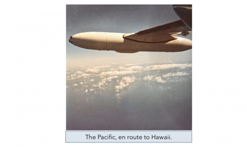 After an hour or two, Bill gave air traffic control our estimated position and asked for the call sign of any airliners that were close above us. Bill then proceeded to radio the airliner, can’t remember which airline company it was, and told him we were on our way to Honolulu and asked for their position so we could cross-check their location against our flight planned DR position. Americans always seem to be fascinated by Australian accents, so the next several radio calls Bill got me to talk to airliners re positioning and we also had a bit of extraneous chit-chat. En route to Hawaii, hours of time were plentiful during cruise. Apart from conversational chit-chat I had with Bill and also on the radio, I utilised much of this time continuing to read through the MU-2 POM in addition to the ground-school info. I knew I would not have as much time available as right now, once the aircraft had been put onto the Australian register and I got back into my normal corporate flying regime. 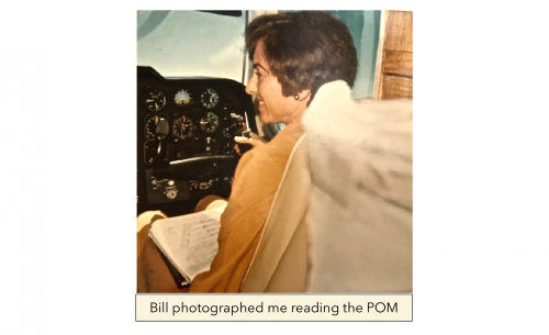 As this aircraft was faster than the Aerostar, I also expected that Garry would most likely expand his flights to more distant locations. At last our navigation instruments picked up Honolulu's (HNL) VOT and VORTAC navaid signals, so we were getting closer to our descent point. The weather so far had not been any problem along our ocean route. For descent I remember there was a small amount of scattered CU (Cumulus cloud) about *2/8ths, so our arrival into HNL was visual, and not on instruments. The flight had taken us 10:20 hours/mins to Honolulu’s International Airport on the island of O’ahu. *cloud amount is given in eighths, 8/8ths being the whole sky covered in cloud. Verbally, for radio talk clarity, eighths are called octas… 2 octas of scattered CU) Just to recap our flight Bakersfield to Honolulu - Time flown was 10:20 hours & mins = 10.3 hours - Distance of 2206 nm (2538 statute miles) ÷10.3 flight hours = 215*kts *G/S (*kts = knots * G/S = groundspeed) - In nil wind conditions it would’ve been 8.5 flight hours = 260kts *TAS ..so our average headwind component was 45 kts. (*TAS = true airspeed) I need to mention that this G/S is an average, as climbing to altitude has to be taken into account which of course is slower and subject to different winds during the climb. So when flying in a south-westerly direction towards the southern hemisphere’s winter season, the *upper level winds can be quite strong, and are usually headwinds at that time of year. On my flights in Australia I’ve had head winds flying from Sydney to Melbourne of 110kts, these winds are called jet-streams. (*upper level winds start with the lowest level being at 18,000ft) At Honolulu we parked in front of a large open style hangar, which had an ‘Air Service Corporation’ signboard attached just below its green roof, I don’t know if this company still exists today. We stepped out into lovely sunshine and stretched our legs. Bill knew his way around the Honolulu airport surrounds, having been there on other ferry flights (or he may have landed at Hilo). I don’t really remember, but I’m sure my first on-ground venture after a 10+ hour flight, would’ve been to the nearest lavatory and next would’ve been to find a cafe or coffee machine to buy a take-away coffee (or coffee-to-go as said in US English). That aromatic liquid bliss I would not have drunk since the previous day, my favourite style being a ‘flat white’ an Australian term unknown in the USA, as they call it coffee and cream. Before leaving the airport apron area Bill promptly organised our refuelling for our next mornings early departure. We took our few travel belongings and headed off to the nearest airport motel accommodation to drop off our bags. I don't recall basic details like, if the accommodation was close enough to walk to from the airport, or if it needed a taxi ride. Eating dry toast was still on the menu. It's funny, when one is restricted in food choice, how thoughts of food often creep into your mind, it does for me anyway. The next morning the winds and weather forecast were still good for the next leg, so Bill flight planned and then we made our way across the tarmac towards the MU-2. On opening the cabin door, oh! shock and horror. Jet A1 fuel flowed out of the door onto the ground!! There was obviously a tank leak from our cabin tanks. Bill enquired at Honolulu’s maintenance companies to find one that could provide engineering assistance to check and pull out the appropriate tank/s for fixing. Meanwhile all the stacked items around the toilet area we pulled out of the aircraft onto the tarmac to clear space for the tank/s removal. Thank goodness it wasn’t raining. 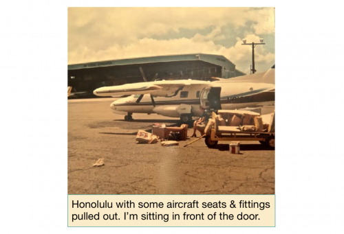 Bill was of the opinion that the tank venting may have been too small. To explain, as fuel was used from these cabin tanks, an empty air space was increasing inside the tank. During cruise at the same altitude the internal cabin pressure remained steady while fuel was used from the tanks. However during descent into Honolulu, as the aircraft cabin pressure slowly started increasing, the tank vents could not equalise the lower pressure inside the tanks at the same rate as the cabin was increasing. So the higher cabin pressure probably caused the empty tank/s to succumb slightly enough to crack the metal, which would most likely be at a weld and so spring a leak. (I don’t know why this leak didn’t occur en route Lakeland to Santa Barbara and to Bakersfield, unless of course the tanks were empty on those flights. Perhaps the tank weakness needed these two pressurisation cycles come to the fore.) So another delay… this time not caused by weather. The maintenance engineers set about completing their task of locating the leak/s and subsequently fixing it and then re-installed the tank/s. After which we could set about re-stacking the aeroplane with all the items we had pulled out. Fitting everything back in was a tight squeeze and bit like a jigsaw puzzle. We refuelled again for the onward flight the next day. I cannot remember if fixing the leak job was completed over one or two days. Anyway the leak was fixed, so the next morning bright and early, we again set about what had become our departure routine. The aircraft was standing waiting for us, looking very stately. But on opening the door, OMG, shock and horror again. Once more the fuel poured out of the door, a repeat of yesterday! (Or the day before). There was obviously a remaining undetected leak/s. With this second leak Bill decided that I should return to Australia by airline as the ferry flight was a single pilot operation which did not require a co-pilot and things were now beginning to look a little chancy. So sadly my ferry flight experience ended in Honolulu. On winging my way back to Sydney again on Qantas, I reflected on my ferrying experience whilst thoroughly enjoying a delicious in-flight meal. From the 16th June, 3 days before departing Lakeland, until the afternoon of the 23rd June when we landed in Honolulu, that’s 7 whole days of eating nothing but dry toast!! It really wouldn’t have mattered to me what food Qantas was serving on that flight (except meat) it would have been yummy, and it was also wonderful to drink a brewed coffee inflight. I don’t remember how many days it took to fix the second leak/s, or how many days it took Bill to fly on to Essendon. Nor do I recall the name of the islands his onward route took him. Sadly at that time, I did not think to ask Bill for a copy of his flight plan as a memento of my Pacific experience. I daresay the smell of jet fuel lingering in the carpets would have curbed Bill’s in-flight smoking. When Smithfield Mall finally took delivery of the aircraft, there was no fuel smell, as I’m sure the carpets would have been replaced. Pilot log books are for logging all the journeys you have flown and their flight times, in mine I also keep all sorts of photos and other memorabilia. I still have the Customs Declaration form for our MU-2 journey and of course my certificates from Flight Safety International for my type training, my temporary Airman Certificate amongst many other mementos from other flights. © 2024 CarolaFeatured Review
Reviews
|
Stats
1175 Views
3 Reviews Shelved in 1 Library
Added on November 25, 2022Last Updated on August 5, 2024 Tags: flying, Pacific Ocean, Honolululu, Hawaii, Mitsubishi MU-2, Carola Hume AuthorCarolaAustraliaAboutHello, Greetings from sunny Australia 👋 ☀️ 🇦🇺 🔹I'm a retired commercial pilot now in my late 70s. (photo taken in 2010) ➤➤ My unparall.. more..Writing
Related WritingPeople who liked this story also liked..
|

 Flag Writing